Satellite images show bedrock and glacier collapsed on Nepal-China border, then rivers flooded
Satellite images reveal a massive bedrock and glacier collapse on the Nepal-China border, triggering catastrophic flooding. Hundreds died and are missing, with villages buried under debris.
Intelligence analysis by Gemini 2.5 Flash Lite
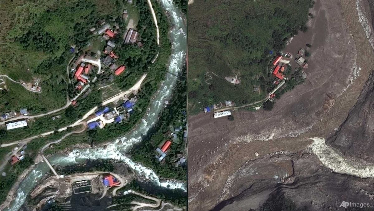
Earth scientists are using satellite imagery to understand a devastating landslide and flood event on the Nepal-China border. The collapse of bedrock and a glacier sent massive debris into a valley, inundating villages and causing widespread destruction along rivers.
Imagine a giant chunk of rock and ice broke off a huge mountain in Nepal. This massive pile of stuff tumbled down, like a giant avalanche, and then mixed with water to create a super-fast mudflow. This flood buried villages and swept away homes, causing a lot of damage.
Analysis
Bedrock and Glacier Collapse
Initial analysis of satellite imagery by geomorphologists Kristen Cook and Dan Shugar indicates that the disaster on the Nepal-China border was not solely a glacial event. While initial observations were hampered by clouds and dust, clearer images revealed a significant collapse of the bedrock beneath a glacier on Langtang Lirung peak. This failure of the mountain's foundation caused a massive chunk of ice and rock to break away, initiating the catastrophic debris flow. Associate Professor Dan Shugar of the University of Calgary described it as a "big bedrock failure that took part of the glacier with it," emphasizing the scale of the geological event.
Debris Flow and Riverine Devastation
The immense volume of debris, comprising boulders and ice, maintained its momentum as it descended into the steep, narrow valley. As the ice melted, it contributed to a powerful surge of water and mud that inundated communities downstream. Geomorphologist Kristen Cook noted that the debris flow was several stories high, transforming the landscape into a "wasteland." The Trishuli River was significantly impacted, becoming much wider and discolored with sediment, indicating the vast amount of material carried by the floodwaters. Towns and villages along the riverbanks, including popular tourist spots like Syapru Besi, were submerged or swept away, with some structures still visible amidst the mud and debris.
Assessing the Impact and Future Risks
The scale of destruction is immense, with hundreds confirmed dead and many more missing, including foreigners and pilgrims. The devastation has left areas unrecognizable, with villages buried and infrastructure destroyed. Alton Byers, a mountain geographer who studies glacial hazards in Nepal, described this as the largest glacier flood he has witnessed. The event underscores the growing vulnerability of Himalayan communities to natural disasters, exacerbated by climate change which contributes to glacial melt and potentially destabilizes mountain slopes. The long-term recovery for the affected regions is expected to take many years, necessitating robust disaster preparedness and mitigation strategies for similar future events.
Key points
- A massive bedrock and glacier collapse occurred on the Nepal-China border.
- The event triggered catastrophic flooding and debris flows, burying villages.
- Hundreds have died, and many more are missing, including foreigners.
- Satellite images reveal the extent of the devastation along river valleys.
- Scientists are analyzing the event to understand its causes and future risks.
The detailed satellite imagery and scientific analysis could lead to improved early warning systems for similar geological events in the Himalayas. Enhanced understanding of bedrock stability and glacial dynamics may help communities better prepare for and mitigate the impact of future disasters.
The scale of the disaster suggests that current disaster preparedness measures in the region may be insufficient. The increasing frequency and intensity of such events, driven by climate change, pose a continuous and escalating threat to life and infrastructure in vulnerable mountain communities.