The Missing Map Of The Sky
Anthropic's Claude Science, in collaboration with astrophysicist Brice Ménard, has produced the first complete map of the sky in ultraviolet (UV) light. This was achieved by combining existing partial datasets from space telescopes and using AI-powered inpainting to predi…
Intelligence analysis by Gemini 2.5 Flash
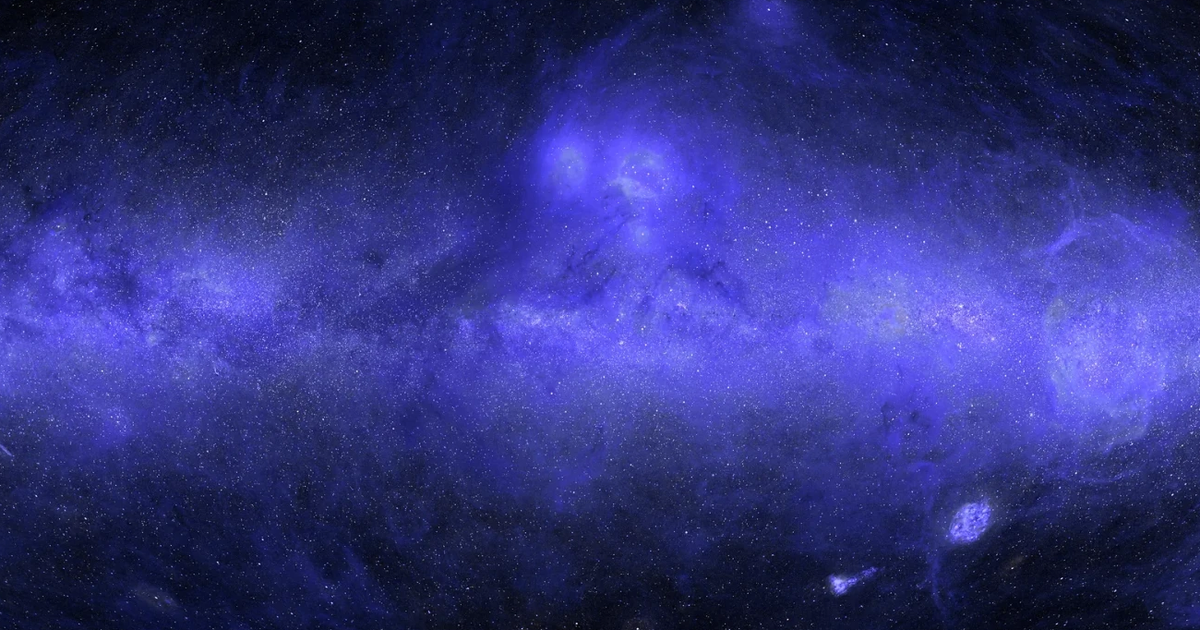
Astrophysicist Brice Ménard partnered with Anthropic's Claude Science to overcome a long-standing challenge in astronomy: completing the UV map of the sky. By orchestrating AI agents to gather, calibrate, and merge disparate UV datasets, and then employing machine learning inpainting techniques, they successfully filled in the previously unobserved regions, offering a comprehensive vi…
Imagine you have a puzzle of the night sky, but a big chunk is missing because some parts were too bright to look at. Scientists usually see the sky in different "colors" like visible light or infrared, and each color shows different things. Now, a smart computer helper called Claude Science teamed up with a scientist named Brice to finish the UV light puzzle. Claude Science looked at all the pieces they had, cleaned them up, and then used what it learned from the existing pieces to guess what the missing parts looked like, just like a super-smart artist filling in a drawing. Now we have a full picture of the sky in UV light!
Analysis
Claude Science
Anthropic's Claude Science played a pivotal role in the ambitious project to construct the first complete ultraviolet (UV) map of the sky. It orchestrated a team of AI agents tasked with the initial, laborious steps of data acquisition and standardization. These agents scoured the web for publicly available astronomical UV surveys, downloading massive collections of images and data points, such as the tens of thousands of images from NASA's GALEX mission. A critical early challenge involved making each survey internally consistent, ensuring that data collected under varying conditions or at different times could be accurately compared, particularly around bright stars where glare needed careful removal.
Following the internal consistency phase, Claude Science's agents tackled the complex task of combining disparate surveys. Datasets from different instruments and telescopes, each capturing the UV sky uniquely, required meticulous cross-calibration, resolution standardization, and mapping onto a common coordinate system. Astrophysicist Brice Ménard provided high-level instructions, allowing Claude to deploy its agent team to manage these intricate technical adjustments, which are typically time-consuming and prone to human error. This automated approach significantly streamlined the integration of diverse observational data.
The most challenging aspect, filling in the roughly one-third of the sky that had never been observed in UV, was addressed using an AI technique called inpainting. Claude Science leveraged its understanding of how parts of an image relate to their surroundings, a skill honed from training on millions of photos. Crucially, it combined this with existing observations at other wavelengths—visible, infrared, and radio—from the two-thirds of the sky that had been mapped in UV. By learning the relationships between UV brightness and these other wavelengths, Claude was able to accurately estimate the missing UV data, effectively completing the celestial map.
GALEX Mission
The NASA GALEX mission, operational from 2003 to 2013, provided the largest single dataset for the UV sky map project, imaging approximately two-thirds of the celestial sphere. Its extensive observations were foundational, offering a broad view of the universe in ultraviolet light. However, despite its significant contribution, GALEX's data was inherently incomplete, leaving substantial gaps that prevented a full understanding of the UV sky.
A key limitation of the GALEX mission was its deliberate avoidance of regions containing very bright stars, particularly those located within the galactic plane of the Milky Way. This precautionary measure was taken to prevent potential damage to the satellite's sensitive detectors. Consequently, the most densely packed and often most interesting parts of our own galaxy remained unobserved in UV, creating significant "holes" in the available data.
These unobserved areas, combined with data from other missions like NASA's Swift and South Korea's FIMS/SPEAR, still left a fragmented picture. While statistical techniques existed to estimate the missing data, the painstaking work involved in meticulous calibrations and sophisticated analyses often meant such projects were deprioritized by astrophysicists in favor of more pressing research. This backlog of "lower-priority" but crucial work highlighted the need for an innovative solution to complete the UV map.
Brice Ménard
Brice Ménard, an astrophysicist at Johns Hopkins University and a researcher at Anthropic, spearheaded the initiative to create the first complete UV map of the sky. Ménard frequently encountered the frustration of having to apologize to his students when teaching astrophysics, as he could only present an incomplete and "full of holes" UV map, unlike the comprehensive views available in visible, infrared, or radio wavelengths. This personal experience underscored the educational and scientific necessity for a complete UV sky map.
Ménard's instructions to Claude Science were conceptually simple but technically demanding: gather all available UV datasets, standardize them, merge them into a single map, and then fill in every unobserved patch of sky. This challenge required not just data aggregation but also sophisticated analytical and predictive capabilities, which Claude Science's AI agents were uniquely positioned to provide. The collaboration exemplifies how human scientific insight can be amplified by advanced AI tools.
The successful completion of the UV map, facilitated by Claude Science, demonstrates a new paradigm for tackling long-standing scientific backlogs. Ménard noted that many fields possess similar projects—those that would explain key concepts or aid other researchers but never gain enough priority to be completed. The ability of AI to automate and accelerate such complex, data-intensive tasks suggests a future where more foundational scientific tools and comprehensive datasets can be realized, freeing human researchers for higher-level inquiry.
Key points
- Anthropic's Claude Science created the first complete UV map of the sky.
- Astrophysicist Brice Ménard collaborated with Claude Science on the project.
- The map combines existing data from missions like NASA's GALEX, Swift, and South Korea's FIMS/SPEAR.
- AI agents were used to gather, calibrate, and merge disparate UV datasets.
- Roughly one-third of the sky, previously unobserved in UV, was filled using AI inpainting techniques.
- Claude Science learned relationships between UV and other wavelengths (visible, infrared, radio) to predict missing data.
This successful application of AI to complete a long-standing astronomical data gap suggests that similar AI-driven approaches could be used to process other complex, incomplete scientific datasets across various fields, accelerating discovery and making advanced research tools more readily available. The new map itself will serve as a valuable educational resource, enhancing understanding of the Milky Way's structure.
While the method is innovative, the reliance on AI for "inpainting" unobserved regions means a portion of the map is predicted rather than directly measured, which could introduce subtle biases or inaccuracies that might only become apparent with future, more comprehensive observational data. The article does not discuss potential limitations or verification challenges for the predicted data.


